Enjoy your time at Springbok Casino
Amatola Trail (Waterfall Trail)
While described as one of the top hiking trails in South Africa, the Amatola Trail is also quite challenging and you'll need to be an experienced and fit hiker to be able to enjoy it. It's certainly worth the effort as you’ll get exposed to some of the most breathtaking mountain scenery you're likely to find in this country. Due to an unusually large number of waterfalls along the way, the trail is also known as the Waterfall Trail.
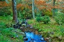
Indigenous Forests, Waterfalls, and Diverse Flora and Fauna
Amatola Trail lies in the Eastern Cape Province, starts at Maden dam near King Williams Town and ends at Hogsback. It takes 6 days to cover the distance of just over 100 km long, though there are shorter alternatives available.
You'll be walking through indigenous rainforest for about half of the trail, and on the way experience diverse flora and fauna this area is home to. Sneezewood, wild olive and lemonwood are found in abundance, as well as numerous fungi, orchids, falling stars, watsonias and red hot pokers. Sounds of cicadas will mix with the singing of cape parrots, knysna louries, barbets, woodpeckers and robins, and additional company potentially provided by giant earthworms, giant golden moles, porcupines, bush pig, bushbuck, otters, baboons and vervet monkeys.
Tough but Rewarding Hiking Experience
On day 1, you'll be hiking for about 15 km and climb 700m through the Pirie indigenous forest rich with flora and fauna. This is the area where in the past wood cutters were spending their lives harvesting yellowwood trees for rail transport. Having spent the night at Gwiligwili Hut, brace yourself for the longest section of this trail. It’s still relatively easy as it leads you along the ridge overlooking the Keiskammahoek valley. An early start will give you an opportunity to explore an impressive waterfall found below your overnight accommodation, the Dontsa Hut, before taking a well-deserved break and relaxing by the open fire.
Another long day follows as you make your way towards the Cata Hut. At this point you're out of the forest and onto a colourful plateau featuring Macchia grassland and zillions of wildflowers. The scenery is spectacular and features an incredible diversity, exposing you to mountains, forests, waterfalls and various flora. Having passed through the Waterfall forest, you'll start ascending towards the Cuta Hut. Take a good rest as the following day will see you climb 600 m to Geju peak, the highest point of the trail. There is an alternate route available, but you'll probably not want to miss spectacular views of the Keiskammahoek river basin, Gaika's Kop, Elandsberg and Hangklip. A steep descent will take you to the top of the Mnyameni gorge, which is where you'll spend the rest of the day climbing through the gorge and swimming in one of its many rock pools, provided by numerous waterfalls.
Having spent the night at Mnyameni Hut, another tough day follows as the trail climbs steeply through indigeneous forest followed by grassland. Cross the ridge and you'll arrive at Wolf river valley. There are many places to swim along the way, the warmer and more inviting ones found in the dense Wolf river forest.
The last day of the hike starts from Zingcuka Hut with yet another series of stunning waterfalls in the Schwarzwald forest. Final 800m ascent to Hogsback peak offers a view of Hogsback and the Tyhume river basin. Follow the path down in that direction and you'll arrive at Hogsback which is where the unforgettable Amatola hiking experience ends.